Laya Gasa Trek Bhutan Tour Details
- Max Elevation you will be reaching at an elevation of 5, 005 meters/16416 feet).
- Min Elevation of the trekking at an elevation of 2, 250 meters/ 7380 feet.
- Difficulty of the trek: Hard
- Best months to trek: May, June, September, October, November
- 13 Days complete trekking excluding cultural tour.
Laya Gasa Trek Bhutan is the best trek that will take you from Paro Valley to Gasa District. You will be passing to higher mountains of the Himalayas. The best part is to check the yak herder’s camps along the trekking route.
On the first day, you will undergo Paro sightseeing places, visiting Rinpung Dzong, the National Museum of Bhutan, Oldest monastery Kyichu Lhakhang.
On the second day you will undergo a Hike to Taksang Monastery Day 3 will kick off Laya Gasa Trek Bhutan. The trek will take you another 12 days to reach Gasa Hot Springs. From Hotspring, you will be driven to Punakha. Punakha sightseeing includes Punakha fortress.
This trekking route offers a great variety of trekking conditions. Starting from picturesque farmland and forests to alpine pastureland. It crosses the high mountain passes (4908 meters / 16,100 ft). You will be camping at good campsites. You can see Bhutan’s most impressive peaks, of which are the most famous Jhomolhari sacred mount and Jichu Drake. Numerous isolated Dzongs and scattered settlements, including the extraordinary village of Laya, and the Gasa hot springs make this trek one of the most popular.
Laya Gasa Trek Map
Itinerary for the Trek
Itinerary for Laya Gasa Trek
Day One: Arrival Paro
The flight to Paro by Druk Air or Bhutan Airlines is one of the most spectacular mountain flights that will provide scenic views of the highest mountains on earth. After lunch enjoy Paro sightseeing. Visit to National Museum of Bhutan which houses many religious relics, works of art, and handicrafts. Next, visit the Rimpong Dzong. Dzongs are large monasteries and district administrative centers, which were once strategic forts. Overnight at your hotel in Paro.
Day Two : Paro Taksang Day Hike
After breakfast hike to Taktsang Monastery, hiking approximately 1.5 to 2 hours uphill. The view of Taktsang Monastery built on a sheer cliff face 900 metres above the valley floor is spectacular. Afterwards, visit 7th Century Kyichu Lhakhang. Overnight at your hotel in Paro.
Day Three: Gunitsawa -Sharna Zampa
Total distance covered: 40 km
Total time taken: 40 mins
Camp Altitude 2,850 m
The day starts from Drukgyal Dzong (2,580m). You can see rice terraces and fields of millet before entering an area of apple orchards and forests. Soon you reach the army post of Gunitsawa (2,810m). This is the last stop before Tibet. The trail again follows the Pa Chu (Paro River), traversing through pine, oak, and spruce forests. After crossing a bridge to the left bank of the river, stop for lunch. Then we continue along the river, climbing upwards through forests, and crossing the river once more before reaching our campsite (3,750).
Day Four: Shara Zampa- Shoi Thangthangkha
Total Distance covered: 22 km
Total time taken: 7-8 hours
Ascent Ascent 770 m, descent 10 m
Campsite altitude at an elevation of 3,610 meters
On this long day, the trekking trail continues with lots of ups and downs. After going uphill through the river valley the valley finally narrows gradually to a mere path that descends to a meadow where a camp will be set up. From here, if weather permits, you will have the first great view of Mount Jomolhari.
Day Five: Shoi Thangthangkha – Jagothang
Distance 19 km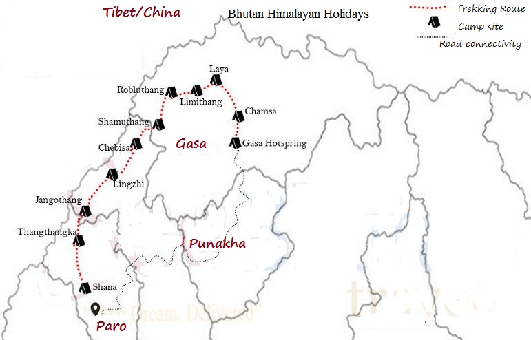
Time 5-6 hours
Ascent Ascent 480 m
Camp Altitude 4,080 m
If you did not see Mt. Jomolhari the previous evening, you will still have a chance to get a great view early this morning. This morning the trek continues up the Paro Chhu valley which widens into patches of alpine meadow and scanty growths of forest.
You will cross an army checkpoint along the way and enjoy a spectacular view of high mountain ridges and snow-capped peaks. In this area, yaks and their herder’s homes become a regular feature of the landscape. Passing the villages of Soe, Takethang, and Dangochang is another asset on this day. After reaching Jangothang, one of the most beautiful campsites of the Himalayas, you will again have a spectacular view of Mount Jomolhari.
Day Six: Jagothang – Rest Day
Day at leisure, enjoying superb views of the south face of Chomolhari and the ruined dzong.
Day 7 -Jagothang to Lingshi
The trail follows a stream before crossing over to the right bank. We now start our climb up to the first ridge with views of Chomolhari, Jichu Drake, and Tserimgang. The trail then crosses a valley until climbing up to Nyele–La Pass (4,700m). We descend gradually to our campsite at Lingshi (4,000m).
Day eight- Lingshi to Chebisa
10km, 5-6 hours
We continue on the trail past Lingshi Dzong, perched on its hilltop, enjoying exhilarating views of hills, the winding river, and magnificent peaks. It is an easy day and a pleasant walk through villages. After lunch, a short walk takes us to Chebisa village, where we camp by the side of a stream of a stream (3,850m).
Day NineChebisa – Shoumuthang
17km, 6-7 hours
Today begins with a stiff climb of nearly four hours up a ridge to Guba–La (4,500m). We descend from the pass-through rhododendrons to our lunch location before crossing a stream and continuing through rhododendron forests and past yak herders’ camp. Tonight’s campsite is at an altitude of 4,250 m.
Day 10- Shoumuthang to Robluthang
18km, 6-7 hours
This trek starts with a climb up to Jari–La Pass (4,700m). We descend from here to Tasharijathang Valley, the summer grazing ground of the rare Himalayan Takin. After crossing a stream, the trail ascends to Robluthang (4,200m) where we set up our camp for the night.
Day 11 Robluthang – Limithang
19km, 7-8 hours
We start the day with a long climb up to Shinji-La Pass (4,900m), enjoying stunning mountain views from the path. After crossing the pass we descend to Lingithang. The last part of today’s trek is steep, with splendid views of Gangchenta peak (6,840). Tonight’s campsite is at an altitude of 4,100 m.
Day 12- Limithang -Laya
10 km, 4 – 5 hours
In the morning we walk to a superb view of Gangchenta Peak in front of our camp. The walk to Laya is very pleasant through a damp forest filled with moss and singing birds. We set up camp on arrival at Laya village, the second-highest settlement in the country, at 3,800m.
Day 13 -Rest Day
Rest Day
Explore Laya village. You can go and visit one of the local houses. Traditional Bhutanese hospitality is extended even to a stranger, and a cup of tea and chang (alcohol brewed from barley) is always offered.
Day 14 -Laya to Tsachu
19km, 8-9 hours
We descend from Laya to the army camp at the side of the Mo chu (Mother river of Punakha), and then walk alongside the river till reaching a bridge. After crossing the bridge, the track winds up and down through juniper and fir forests. We camp in the forest at Chamsa (3, 800m).
Chamsa – Gasa Tshachu
14km, 6-7 hours
After a 30-minute walk over flat land to Bele-La Pass, it’s downhill to Gasa Tshachu. We have lunch at Gasa village (2700m), and afterward visit the village and Gasa Dzong. The Dzong was built in the 17th century. We then descend to Gasa Tshachu (hot spring), where we set up our camp (2,200m).
Day 15 -Rest Day at Hotspring
Rest day
After a long trek, this is the place to relax! Enjoy a hot bath and try some of the local beer.
Day 16- Hotspring to Punakha
Drive through scenic mountains from Gasa to Punakha (3-4 hrs). Punakha was the ancient capital of Bhutan. Overnight at your hotel in Punakha.
Day 17-Punakha-Thimphu
Punakha – Thimphu-Drive to Bhutan’s capital, Thimphu via the Dochu-La pass (3,100 meters), which on a clear day offers an incredible view of Himalayan peaks (about 3 hrs total driving time). The drive through the countryside affords a glimpse of everyday life in this most remote of Himalayan kingdoms.
In the Dochu-La area, there are vast Rhododendron forests that grow to tree size and bloom in late April/early May covering the mountains in a riot of glorious spring color. After lunch, enjoy the afternoon at leisure. Overnight at your hotel in Thimphu.
Day 18-Thimphu Sightseeing
Full sightseeing
Day 19- Thimphu- Paro
Paro sightseeing- Visit the School for Arts and Crafts, The National Library housing a collection of 8th-century scriptures, the Traditional Paper Factory, and the Folk Heritage Museum. If your visit coincides with the weekend, you can walk through the Thimphu Market. Late afternoon transfer to Paro for overnight.
Day 20- Paro-Departure
Breakfast in the hotel, then drive to the airport for a flight to your onward destination. Tashi Delek.